Slave huts, sugar cane and the Landscapes of Misery
While traveling across Louisiana, the low coastal delta where the Mississippi floods across the land it is hard not to reflect on the overly simplistic images pop culture paints of the South. Yes there are old timber houses, pickup trucks and churches everywhere. Some of them in traditional steeple form while others are cinder block bunkers and tin sheds with hand painted signs advertising God and hours of worship. The landscape feels old and wet, with oak trees dripping Spanish moss and narrow roads flanked by water and swamp cypress. Signs of human occupation are everywhere, from the above ground whitewashed graves that keep loved ones out of the high water table to ads for BBQ, ice houses and shrimp.

There is a fragile feeling to the human occupation of this land, as if the water and vegetation could take back the dwellings and roads at any moment. Many buildings are overgrown and abandoned. In some cases entire residential blocks have retreated to a landscape of long grass and weeds.
As much as swamps, pick ups and churches are what we have come to expect from the South, the South is much more complex than pop culture often acknowledges. As my brother and I travelled through Louisiana it was clear that it is the epicentre of all things Cajun and Creole with place names like Lafayette, Thibodaux and Beaux Bridge. There is a rich cultural history here that comes from the many diverse groups of people making a life in the swamps and waterways after fleeing persecution. The diversity of cultures is tangible in the local music, dancing, food, dialects and place names and Louisiana is a richer place for it.

This is not my first visit here but I get drawn back to this place. There’s a frontier spirit here that you would struggle to find anywhere else in the US. Like all cultures and places you get the most out of them if you go in with an open mind, ready to listen and learn without judgement. A conversation with a Lafayette local during a late night of whiskey, music and political debate in a Cajun dance hall had us making a detour on our road trip. It led us down a narrow, dead end country road called Laurel Valley and it was flanked by tall sugar cane and water.

The Laurel trees were long gone, if they had ever been there. Maybe the name was chosen because it sounded pretty? However Laurel Valley Road was not leading to a place most would consider pretty. I am not sure I would have heard about this place if it was not for the whiskey the night before. This site was miles off the main road and hidden behind a sea of tall sugar canes on a road that heads nowhere, it would be hard to find by accident.
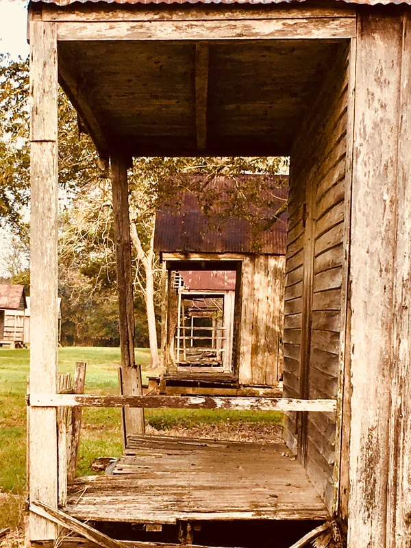
The sugar cane created a narrow viewing corridor limiting views across the landscape, the first indication that we had got to our destination was a giant rust coloured crane emerging from the horizon of sugar canes. As we came around the bend we got our first glimpse of what we had come to see; rows and rows of weathered timber huts neatly lined up on either side of what I imagine was once a dirt road.
This was a village of slave huts with a clear grid layout, narrow streets and front porches all looking towards each other. It looked like someone had followed the urban lexicon for designing slave quarters - most modern urban designers would have approved the layout. You could still see the old brick sugar mill, now overgrown, and the crane that moved bundles of sugar cane from the collection point into the factory when the plantation was operating.

We stood on the shoulder of the road, on the right side of a barbed wire fence. The “no trespass” signs sent a clear message which we wanted to respect. The photos tell the story and I am not going to describe the slave village in detail. What was for me more powerful and unexpected was my emotional reaction to the place. We looked at these neat rows of huts, fascinated that this place actually still existed, yet saddened that it had a need to exist in the first place.

I had always known about the period of history that this stark landscape represents but it’s different seeing it in person. For me it embodies a history of misery for so many - for the slaves that were forced against their will to work and live here, and also for the desperate share farmers who lived in these same huts following the abolition of slavery, for these people had little hope of achieving any more than just existing. It was a landscape of misery that I could not have simply read about and understood as deeply as seeing this place and reflecting on its history.

Standing on the side of the road I felt like I was in a place I really should not have been; it felt like trespassing on someone’s private memories and it was uncomfortable. In the course of an hour and in the sweaty heat of the Southern morning about half a dozen pickup trucks drove by, slowing as they passed. Maybe they just wanted to pass by us safely, or maybe they wanted to see who these strangers were standing in their backyard, peering into this uncomfortable reminder of the past. I felt like everyone who passed me by knew that I should not have been there, that this was not part of my history and I was viewing it without their permission. They all returned a wave, which I offered because I did not know what else to do.
I feared criticism for being there in the first place and I expected someone to lean out of the pickup window and tell us to go away. No one did, they all continued on their way. I felt acutely out of place and equally a deep feeling for the wrong that this landscape represented. However feeling uncomfortable and challenged is not a bad thing and in that moment I also felt connected to this period of history.

This experience made me reflect on the importance of retaining these landscapes of misery. It is not comfortable landscape by any means but sometimes there is value in having such reminders of the past so that we don’t repeat the sins of our fathers, so that there can be a deeper empathy for the people wronged. I felt appreciation to the land owners and community that preserved this village so that I was allowed to view it, even if it was only from the side of the road.
Dwelling on the experience back home in San Antonio I was reflecting on the questions: “does New Zealand have the same types of landscapes? Is it even fair to try and compare a landscape of slavery with any landscape in New Zealand?” I think the answer is probably yes because misery is in the eye of the beholder. I know that these landscapes do exist from working and traveling in New Zealand.
You have to acknowledge the cultural lens that you view a landscape through and that one person’s war memorial is another’s pillar of hate, a constant reminder of the wrongs done to their people. One community’s airport runway is another’s desecrated burial ground, one community’s rose garden is another’s historical meeting site flattened and disrespected. These New Zealand landscapes exist but are not often acknowledged as often as maybe they should be.

Landscapes are political and sometimes they represent a period of our past that we might want to forget or rewrite. However as in the case of the Laurel Valley slave village there may be a case for retaining these sites if it helps acknowledge the past and heal communities. Landscapes could be used as part of a truth and reconciliation type of process but that can only happen if they still exist. A starting point might be to at least acknowledge and record the existence of such cultural landscapes. I know that there is real fear in identifying sites of importance on all sides but unless these sites are identified how do we move forward as a community in acknowledging a fair and equitable record of our past?
Not all landscapes of misery have a place in our society. It is an important question for communities, local government, city managers and designers to consider and question how these landscapes are managed, edited or removed. How do we appropriately acknowledge the past without being seen as supporting symbols of hate?
Only the community who has the deep and intimate understanding of the history of that place. can identifying a landscape as a record of misery and judge the merits of the place and its future role in the community. I understand that this is a challenging and time consuming process often because there is more than one group that has a significant history and role to play in the sites future. The process has to be inclusive, transparent, robust and honest.
It has been a challenging, passionate and sometime violent process in the US. The debate on the confederate flag flying above public buildings, and statues of confederate leaders in public parks has tested the modern American resolve but was lead by significant debate and collaboration with the community to get to the final outcomes. It is hard not to admire the bravery of these communities taking on this challenge.

Its not about protecting and keeping all landscapes that have painful pasts or glorify an uncomfortable period of time. Maybe for some landscapes a bulldozer is the best solution but for another a joint partnership in the land management or just a simple recognition of the past wrongs be a step in the right direction, thats for the community to decide.
No matter the outcome it is important that the process of identification, communication and transformation is not only used to heal communities but to inform future generations of the values we have in the present which hopefully includes transparency and inclusion in our public spaces. The message we send today in how we address these landscapes of misery will be the same message that we will be judged on by future generations, hopefully we can get it right.
You can view more photos and videos from Craig Pocock here.